
The National Weather Service on Friday, Jan. 10, 2020, issued a ‘Special Weather Statement,’ warning of a cold weather pattern coming Sunday night, and the chance of lowland snow into next week.
Temps will start dipping down into the 20s this Sunday night (Jan. 12), so be sure to be ready, and don’t forget the four P’s of cold weather: Pets, Pipes, Plants, and People:
-
- PETS: Bring your pets inside for overnight shelter, either inside a household or garage. If you can’t bring your animals inside, make sure they have shelter, blankets, or something to keep them warm, as freezing temperatures will be likely for several hours at a time.
- PIPES: Seal any cracks or holes on old pipes to avoid them from freezing up. Add extra insulation to all pipes. Foam rubber or fiberglass sleeves will work great as extra insulation. Another thing to do for indoor pipes is to open kitchen and bathroom cabinet doors to allow warm air to the pipes. If pipes freeze, water will not flow and pipes could possibly burst.
- PLANTS: Bring any plants inside your household or garage. Frost can begin to form on many plants at around 36°F. If you can’t bring your leafy friends inside, you can protect them with extra mulching.
- PEOPLE: If you have to spend any time outdoors in cold temps, remember to bundle up to avoid frostbite and hypothermia. Be sure any elderly relatives or neighbors are safe and warm also!
“The cold air will spread south through the rest of Western Washington Sunday night,” forecasters said. “The leading edge of this cold air is called a modified arctic front. It is not unusual for snow to fall with this type of cold front as it moves south down the I-5 corridor. Snow amounts tend to be light with modified arctic fronts but falling temperatures can lead to icy roads after even light snowfall.”
SEVERE WEATHER SHELTER WILL OPEN SUNDAY NIGHT
The City of Burien is working with Highline United Methodist Church, and will open a Severe Weather Shelter Sunday night, Jan. 12.
It will remain open through Tuesday, Jan. 14:
Volunteers can sign up here: https://signup.com/client/invitation2/secure/2691152/false#/invitation
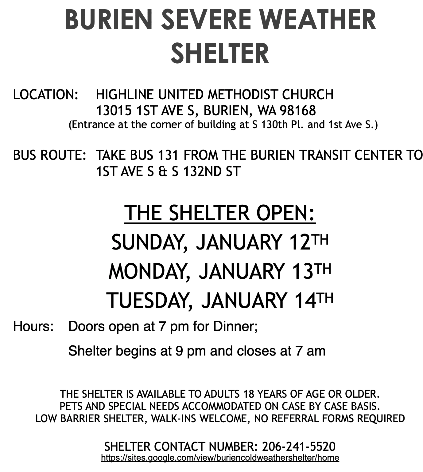
Retweeting w/ update about plan for SWS in Burien 1/12-1/4 at Highline United Methodist Church (13015 1st Ave. S.) 9 p.m.-7 a.m. 18+. NOTE: weather changes, so will these postings. Follow @CrisisCXNs for updates, offer help as you can to ppl providing shelter, those left outside. https://t.co/0yo9Vss9G7
— SKCHomelessCoalition (@Homeless2Housed) January 11, 2020
Here’s the full Special Weather Statement:
Special Weather Statement
National Weather Service Seattle WA
353 PM PST Fri Jan 10 2020
…WESTERN WASHINGTON WILL SEE A COLD WEATHER PATTERN SET UP ON
SUNDAY AND THERE WILL BE A CHANCE OF LOWLAND SNOW INTO NEXT
WEEK…
Cold air will be shifting south through British Columbia over the
weekend. A weather system on Sunday will arrive as cold Fraser
outflow develops. Precipitation should change to snow around
Whatcom county and the San Juans on Sunday. Cold wind chill will
develop and blowing snow with poor visibility will be possible
into early next week in the Bellingham area and San Juans.
The cold air will spread south through the rest of Western
Washington Sunday night. The leading edge of this cold air is
called a modified arctic front. It is not unusual for snow to fall
with this type of cold front as it moves south down the I-5
corridor. Snow amounts tend to be light with modified arctic
fronts but falling temperatures can lead to icy roads after even
light snowfall.
Another area that can see enhanced snowfall during Fraser outflow
is around Port Angeles and along the Strait of Juan de Fuca. Cold
air picks up moisture as it crosses the northern inland waters and
snow falls in the northerly flow as it pushes into the north
portion of the Olympics.
Areas along the coast and across Southwest Washington will not
avoid the cold snap developing early next week. A weather system
moving into Oregon on Monday could affect southwest Washington.
Stay tuned to updated weather forecasts and prepare for potential
wintry weather.
www.weather.gov/seattle
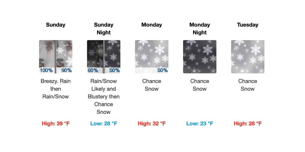
Here’s the latest 7-day forecast:
-
- Tonight: Rain before 10pm, then showers after 10pm. Low around 40. South southwest wind around 18 mph, with gusts as high as 24 mph. Chance of precipitation is 100%. New precipitation amounts between a quarter and half of an inch possible.
- Saturday: Showers, mainly before 4pm, then rain likely after 4pm. High near 43. North northwest wind 9 to 14 mph becoming light and variable in the afternoon. Chance of precipitation is 90%. New precipitation amounts between a tenth and quarter of an inch possible.
- Saturday Night: Rain. Low around 39. South southwest wind 6 to 13 mph. Chance of precipitation is 80%. New precipitation amounts between a tenth and quarter of an inch possible.
- Sunday: Rain. High near 42. South southwest wind 15 to 18 mph, with gusts as high as 24 mph. Chance of precipitation is 90%. New precipitation amounts between a tenth and quarter of an inch possible.
- Sunday Night: Rain and snow likely, becoming all snow after 10pm. Mostly cloudy, with a low around 29. Blustery. Chance of precipitation is 70%. New snow accumulation of less than a half inch possible.
- Monday: Snow likely, mainly before 10am. Cloudy, with a high near 33. Chance of precipitation is 60%. New snow accumulation of less than a half inch possible.
- Monday Night: A chance of snow. Mostly cloudy, with a low around 23.
- Tuesday: A chance of snow, mainly before 10am. Partly sunny, with a high near 28.
- Tuesday Night: A chance of snow, mainly after 10pm. Mostly cloudy, with a low around 22.
- Wednesday: A chance of snow. Cloudy, with a high near 29.
- Wednesday Night: Snow likely. Cloudy, with a low around 24.
- Thursday: A chance of snow. Cloudy, with a high near 33.
- Thursday Night: A chance of snow. Cloudy, with a low around 28.
- Friday: A chance of rain and snow. Mostly cloudy, with a high near 34.

Recent Comments